
No caption
IMG_7932.JPG
Details
Wednesday, May 21, 2025 · 1:33 PM
39.39477, -120.02133· 1652m
Location Context
1 / 5
USGS Topo
No elevation data
FEMA Flood
No flood data
OSM Infra
No address data
USDA Soil
No soil data
USGS Hydro
No hydro data
Apple iPhone 16 Pro
iPhone 16 Pro back triple camera 6.765mm f/1.78
6.764999865652793mmf/1.7799999713880651/1980sISO 64
Flash did not fire, compulsory flash mode
Show all EXIF (43 fields)
ApertureValue1.6638
BrightnessValue8.7899
ColorSpace65535
CompositeImageGeneral Composite Image
ExifImageHeight3024
ExifVersion2.3.2
ExposureCompensation0
ExposureModeAuto
ExposureProgramNormal program
FlashpixVersion1.0
FocalLengthIn35mmFormat48
GPSDateStamp2025:05:21
GPSDestBearing354.4430
GPSDestBearingRefTrue North
GPSHPositioningError5.1621
GPSImgDirection354.4430
GPSImgDirectionRefT
GPSSpeed0.0438
GPSSpeedRefK
GPSTimeStamp20:33:18
HostComputeriPhone 16 Pro
latitude39.3948
LensInfo2.2200, 15.6600, 1.7800, 2.8000
LensMakeApple
longitude-120.0213
MeteringModePattern
ModifyDate2025-05-21T13:33:18.000Z
OffsetTime-07:00
OffsetTimeDigitized-07:00
OffsetTimeOriginal-07:00
ResolutionUnitinches
SceneCaptureTypeStandard
SceneTypeDirectly photographed
SensingMethodOne-chip color area sensor
ShutterSpeedValue10.9514
Software18.5
SubjectArea{"0":2011,"1":1508,"2":1106,"3":665}
SubSecTimeDigitized564
SubSecTimeOriginal564
WhiteBalanceAuto
XResolution72
YCbCrPositioning1
YResolution72
AI Analysis
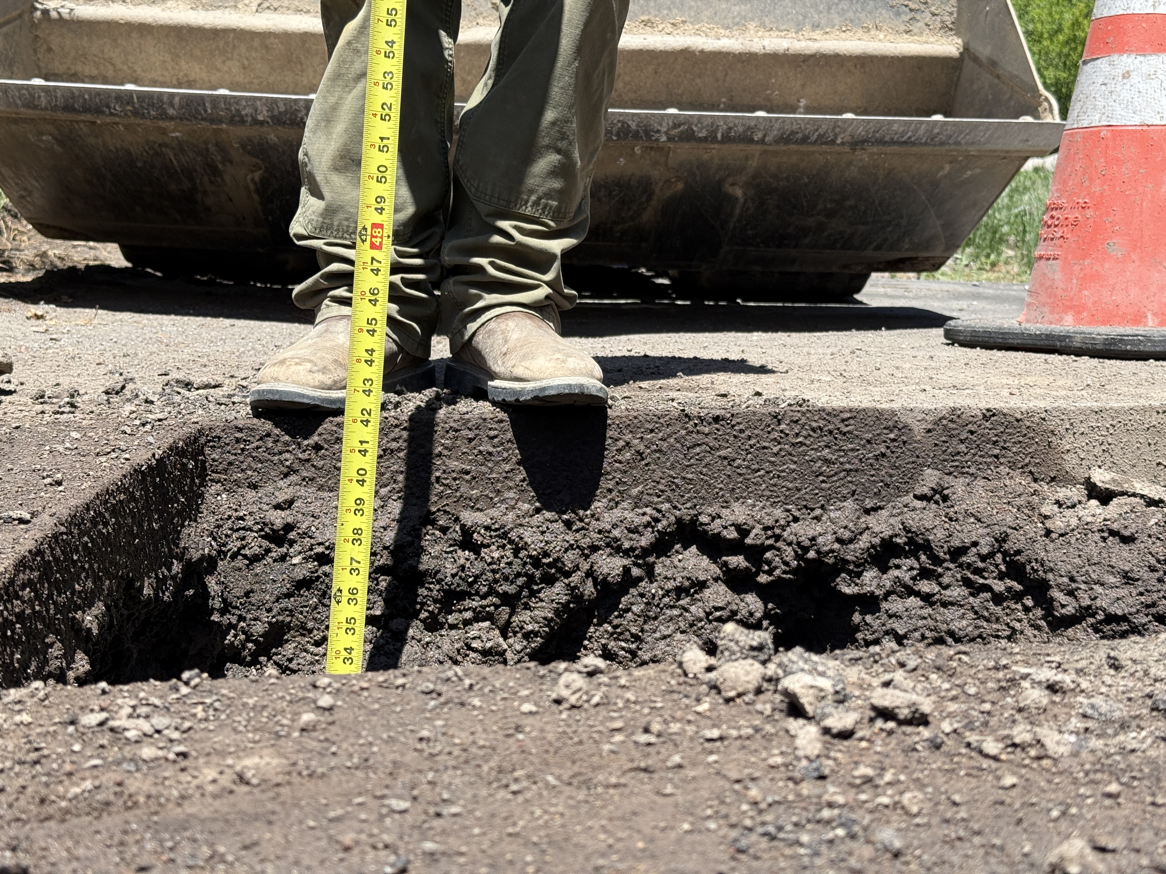
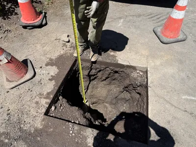
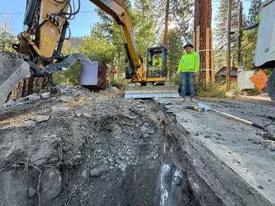
The image shows a person holding a measuring tape to gauge the depth of an excavation. The tape indicates a depth of approximately 48 inches. A section of soil has been excavated, and a traffic cone is placed nearby. The ground appears to be dirt or gravel, with loose material around the excavation edges.
excavation
dirt or gravel surface around excavation bright, sunny conditions open access to excavation area
Traffic cone visible for safety; open trench present.
Equipment & Materials
AI Tags
Analyzed Apr 21, 2026
Nearby Photos
1m
trenching
trenchingtrench
excavator
1m
trenching
road-trenchingutility-excavation
excavator
2m
pipeline installation
pipeline-installationtrenching
skid steer
2m
excavation
pothole-utility-locatingdepth-measurement
tape-measure
3m
pipeline installation
conduit-installationtrenching
conduits
3m
pipeline installation
conduit-installationduct-bank-work
conduit
3m
excavation
pothole-utility-locatingdepth-measurement
vacuum-truck
3m
survey layout
surveyinglayout
truck
3m
trenching
trenchingexcavation-work
excavator
3m
trenching
trenchingexcavation
excavator