
No caption
IMG_9759.JPG
Details
Wednesday, August 27, 2025 · 11:25 AM
39.39475, -120.02112· 1660m
Location Context
1 / 5
USGS Topo
No elevation data
FEMA Flood
No flood data
OSM Infra
No address data
USDA Soil
No soil data
USGS Hydro
No hydro data
Apple iPhone 16 Pro
iPhone 16 Pro back triple camera 6.765mm f/1.78
6.764999865652793mmf/1.7799999713880651/387sISO 80
Flash did not fire, compulsory flash mode
Show all EXIF (43 fields)
ApertureValue1.6638
BrightnessValue6.2579
ColorSpace65535
CompositeImageGeneral Composite Image
ExifImageHeight4284
ExifVersion2.3.2
ExposureCompensation0
ExposureModeAuto
ExposureProgramNormal program
FlashpixVersion1.0
FocalLengthIn35mmFormat24
GPSDateStamp2025:08:27
GPSDestBearing299.9556
GPSDestBearingRefTrue North
GPSHPositioningError17.5005
GPSImgDirection299.9556
GPSImgDirectionRefT
GPSSpeed6.1381
GPSSpeedRefK
GPSTimeStamp18:25:44
HostComputeriPhone 16 Pro
latitude39.3948
LensInfo2.2200, 15.6600, 1.7800, 2.8000
LensMakeApple
longitude-120.0211
MeteringModePattern
ModifyDate2025-08-27T11:25:46.000Z
OffsetTime-07:00
OffsetTimeDigitized-07:00
OffsetTimeOriginal-07:00
ResolutionUnitinches
SceneCaptureTypeStandard
SceneTypeDirectly photographed
SensingMethodOne-chip color area sensor
ShutterSpeedValue8.5956
Software18.6.1
SubjectArea{"0":2851,"1":2137,"2":3141,"3":1884}
SubSecTimeDigitized077
SubSecTimeOriginal077
WhiteBalanceAuto
XResolution72
YCbCrPositioning1
YResolution72
AI Analysis
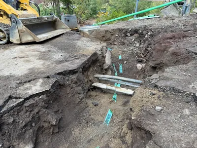
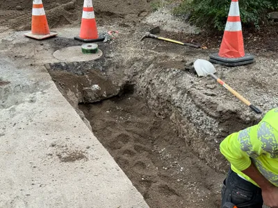
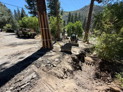
The image depicts an open trench with several buried conduits partially exposed along its bottom. A front loader is positioned at the edge of the trench, suggesting recent excavation work. Green marking tape is present along the conduits, which may indicate warning of buried utilities. The surrounding area has uneven ground due to excavation activities.
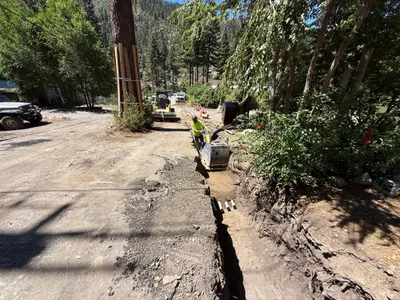
trenching
uneven ground with trenches and excavated soil natural daylight limited access due to excavation, machinery present
Safety features are not visible in the frame.
Equipment & Materials
AI Tags
Analyzed Apr 21, 2026
Nearby Photos
1m
trenching
trenchingexcavation
construction machinery
2m
other
document-reviewindoor-activity
documents
2m
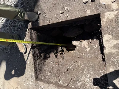
excavation
pothole-utility-locatingcylindrical-object
buried-potential-pipe
2m
trenching
trenchingmanual-excavation
shovel
2m
trenching
trenchingroadside-construction
excavator
2m
excavation
trenchingtree-protection
dump-truck
2m
other
pipe-installationculvert-work
soil
2m
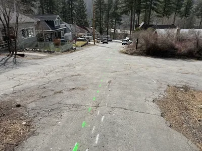
survey layout
road-markingssite-survey
parked-vehicles
3m
excavation
utility-locatingpothole-excavation
tape-measure
3m
trenching
trenchingexcavation
excavator