
No caption
IMG_6890.JPG
Details
Wednesday, March 26, 2025 · 3:17 PM
39.39143, -120.02080· 1678m
Location Context
1 / 5
USGS Topo
No elevation data
FEMA Flood
No flood data
OSM Infra
No address data
USDA Soil
No soil data
USGS Hydro
No hydro data
Apple iPhone 16 Pro
iPhone 16 Pro back triple camera 6.765mm f/1.78
6.764999865652793mmf/1.7799999713880651/3096sISO 80
Flash did not fire, compulsory flash mode
Show all EXIF (43 fields)
ApertureValue1.6638
BrightnessValue8.9724
ColorSpace65535
CompositeImageGeneral Composite Image
ExifImageHeight3024
ExifVersion2.3.2
ExposureCompensation0
ExposureModeAuto
ExposureProgramNormal program
FlashpixVersion1.0
FocalLengthIn35mmFormat48
GPSDateStamp2025:03:26
GPSDestBearing234.7069
GPSDestBearingRefTrue North
GPSHPositioningError4.0315
GPSImgDirection234.7069
GPSImgDirectionRefT
GPSSpeed0.3178
GPSSpeedRefK
GPSTimeStamp22:17:32
HostComputeriPhone 16 Pro
latitude39.3914
LensInfo2.2200, 15.6600, 1.7800, 2.8000
LensMakeApple
longitude-120.0208
MeteringModePattern
ModifyDate2025-03-26T15:17:32.000Z
OffsetTime-07:00
OffsetTimeDigitized-07:00
OffsetTimeOriginal-07:00
ResolutionUnitinches
SceneCaptureTypeStandard
SceneTypeDirectly photographed
SensingMethodOne-chip color area sensor
ShutterSpeedValue11.5962
Software18.4
SubjectArea{"0":2011,"1":1508,"2":1106,"3":665}
SubSecTimeDigitized593
SubSecTimeOriginal593
WhiteBalanceAuto
XResolution72
YCbCrPositioning1
YResolution72
AI Analysis
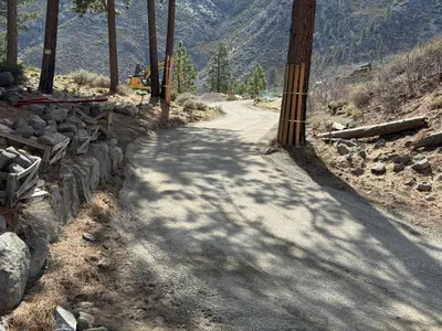
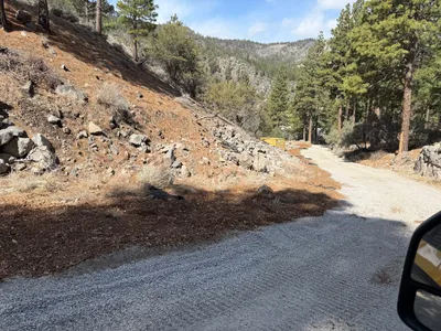
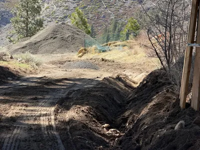
The image shows a dirt access road with a slight curve and a tree-lined perimeter. Protective wood panels are strapped to some trees, and a piece of heavy machinery is visible near the trees on the left side. Rocks and wooden braces are positioned alongside the road edge, indicating potential reinforcement or erosion control efforts.
site-grading
dirt road with some rock reinforcement sunny lighting casting shadows road partially accessible, machinery nearby
No specific safety controls are visible in the frame.
Equipment & Materials
Analyzed Apr 21, 2026
Nearby Photos

1m
paving surface restoration
road-gradingsurface-preparation
roller-compactor
2m
site grading
site-gradingroad-preparation
bulldozer
6m
swppp erosion control
erosion-controlaccess-road
gravel
6m
site grading
road-constructiongrading
front-loader
8m
other
access-roadsite-preparation
gravel
9m
site grading
access-roadretaining-wall
truck
9m
trenching
excavationtrenching
excavator

12m
site grading
site-gradingearthwork
excavator
12m
site grading
site-gradingearth-moving
excavator
13m
trenching
trenchingexcavation
gravel