
No caption
IMG_0191.JPG
Details
Monday, September 15, 2025 · 10:40 AM
39.39456, -120.02123· 1654m
Location Context
1 / 5
USGS Topo
No elevation data
FEMA Flood
No flood data
OSM Infra
No address data
USDA Soil
No soil data
USGS Hydro
No hydro data
Apple iPhone 16 Pro
iPhone 16 Pro back triple camera 6.765mm f/1.78
6.764999865652793mmf/1.7799999713880651/138sISO 100
Flash did not fire, compulsory flash mode
Show all EXIF (43 fields)
ApertureValue1.6638
BrightnessValue4.2211
ColorSpace65535
CompositeImageGeneral Composite Image
ExifImageHeight4284
ExifVersion2.3.2
ExposureCompensation0
ExposureModeAuto
ExposureProgramNormal program
FlashpixVersion1.0
FocalLengthIn35mmFormat24
GPSDateStamp2025:09:15
GPSDestBearing90.1816
GPSDestBearingRefTrue North
GPSHPositioningError35.0475
GPSImgDirection90.1816
GPSImgDirectionRefT
GPSSpeed0
GPSSpeedRefK
GPSTimeStamp17:40:41
HostComputeriPhone 16 Pro
latitude39.3946
LensInfo2.2200, 15.6600, 1.7800, 2.8000
LensMakeApple
longitude-120.0212
MeteringModePattern
ModifyDate2025-09-15T10:40:42.000Z
OffsetTime-07:00
OffsetTimeDigitized-07:00
OffsetTimeOriginal-07:00
ResolutionUnitinches
SceneCaptureTypeStandard
SceneTypeDirectly photographed
SensingMethodOne-chip color area sensor
ShutterSpeedValue7.1134
Software26.0
SubjectArea{"0":2853,"1":2140,"2":3142,"3":1881}
SubSecTimeDigitized657
SubSecTimeOriginal657
WhiteBalanceAuto
XResolution72
YCbCrPositioning1
YResolution72
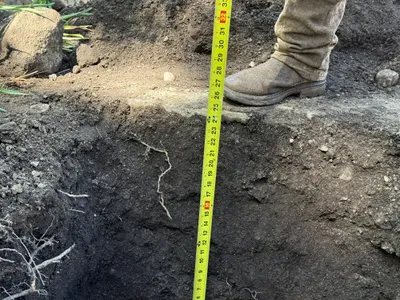
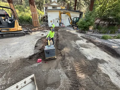
AI Analysis
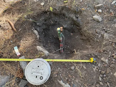
The image shows a small excavated hole with a grounding rod vertically positioned in the center. A measuring tape is extended across the site, indicating a measurement activity. A concrete grounding cap engraved with 'LYNCOLE XIT GROUNDING' lies nearby. The surrounding area has loose soil and some scattered rocks, indicating site disturbance.
excavation
loose soil with rocks natural daylight open site with no visible barriers
Safety features are not visible in frame.
Equipment & Materials
AI Tags
Analyzed Apr 21, 2026
Nearby Photos
2m
excavation
excavationboulder-moving
excavator
2m
excavation
excavation-activityearth-moving
wheelbarrow
3m
trenching
trenchingduct-bank-installation
excavator
4m
trenching
trench-measurementutility-locating
measuring-tape
5m
site grading
surface-gradingcompacting
bulldozer
6m
trenching
trenchinginspection
hand tools
7m
pipeline installation
pipeline-installationtrenching
PVC pipes
7m
trenching
trenchingcompacting
excavator
7m
trenching
trenchingmanual-labor
excavator
7m
inspection documentation
inspectionpavement-assessment
wooden braces